Driving to Key West

a tree in Miami

a tree in Miami

The airplane landed at 5:30 am and we were told to go to baggage claim on level one – J5. We grabbed our bag and were on the shuttle heading towards the car rental on level 4 at 6:00 am. Instead of a military discount we got upgraded from some compact economy car to a silver Chrysler 200C convertible parked in spot 29C on level 2. The mustang next to it was tempting, but there is someone at the gate to make sure you grabbed the right car.

Caleb has us on the roads of Miami driving away from the sun. We are looking for Dick’s Sporting Goods that doesn’t open until 9:00. We will have sandwiches at the Corner Bakery Café and get our grocery shopping done at Publix – junk food, water, and PBJs – by 8:20. We sit in the car and read while we wait. We purchased a gas can for cooking food in out Jetboil as soon as the store opened.

in the convertible in Miami

in the convertible in Miami

We take the toll road to Hwy 1 South that will take us through The Keys to Mile Marker Zero with no sightings of crocodiles or Key Deer, just lots of construction. We stop at Wahoo’s – a place we stopped at last time to get a picture of the sunrise. The view is different this time, but the emotions are just as happy – we are in a convertible on a Monday morning driving on one of the Top Ten scenic drives in the U.S.

We average 45 mph and spend the morning driving the 161 miles from the airport to Mile Marker Zero. Once in Key West I park us on Eaton Street and we walk around to the Oldest Schoolhouse out here, Mallory Square (popular for sunset) where we see some Buddhists, and the Historical Military Memorial. After trying Naked Turtle rum with lime at El Meson de Pepe we walk to the end of the boardwalk to find where we will be leaving from in the morning – the Key West Bight Ferry Terminal.

playing with our food in Miami

playing with our food in Miami

On our way to dinner at BurgerFi, a restaurant only two months old in Key West, we stop at the Fort Jefferson Museum which has a large model inside of the fort as it appeared in 1846 along with historical information and photos. When we’re done with that we make our way to Duval Street. We each order a quinoa burger and Cajun fries to share. As if that wasn’t enough Caleb thinks we need a key lime pie concrete – vanilla custard and pie. I agree and we eat it while we watch the bartender and owner take inventory of the alcohol.

I’m so full my stomach hurts. I get to walk some of it off on the way back to the car as we pass a Cuban cigar shop and a bakery that makes cakes look like burgers. Then we drive to the airport to gauge how much time Caleb will need after dropping me and the bags off to deliver the rental car and meet me at the pier on foot before the catamaran leaves at 7 or 8 in the morning. With the lack of sleep and a meal coma coming on I’m ready for the tent.

in front of Wahoo's in Islamadora

in front of Wahoo’s in Islamadora

Tonight’s campsite will be on Sigsbee Park, a military installation, and right on the water – with chance of flooding. The trees will block most of the sunset, but we will have the next few days unobstructed. The site cost us $13 and 20 minutes worth of questioning – but it’s worth it – the camp host gives us each a chocolate cake pop. Time to put my feet on seagrass and coral and then my head on a pillow. Tomorrow’s excitement will come early.

Posted in Animals, Camping, Food, History, People, Places, Travel, Water | Tagged , , , , , | Leave a comment

Going to Miami

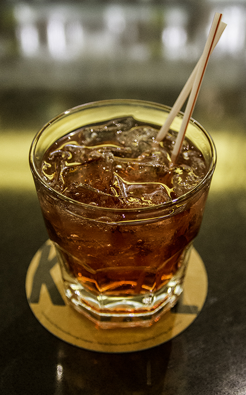
cranberry vodka

cranberry vodka

To help get me through the morning while I waited for all my electronics to charge I posted two days from a trip we took in April 2012. I took a shower at 4:00 pm, and Dan was reversing us out of the driveway 45 minutes later. We get to the airport with 2.5 hours to spare – which is a good thing. Dan dropped us off at the Delta Airlines in Terminal 2 and we needed the Commuter Terminal – a shuttle drive away.

Printing our tickets is easy. We have one checked bag that will cost us $25 and a carry-on each. Going through security everyone is elected to go through their new metal detector and that too is quick. On the other side I get my traditional cranberry vodka and Caleb gets a Tower 10 IPA. While at the bar we talk with an alcohol beverage insurance agent for stadiums and arenas that get sued all the time for bartenders over serving, a public defender that loves her 25 case load job, and a guy going to Costa Rica on business.

There’s also a guy that just got back from Mexico and he used his debit card down there without telling his bank. They cancelled his card after he tried using it here. We help him pay for the beer that he started drinking when he thought there wouldn’t be a payment issue. He spent the rest of his time on the phone and then thanked us before we took off excitedly outside past the first smaller plane to the bigger one with the line of people walking towards it.

Caleb sleeping on the way to Miami

Caleb sleeping on the way to Miami

Our flight loads early on our 80-seat plane that will take us to Los Angeles. The bathroom, or lavatory, is larger than should be expected on a smaller plane. It seems as if we are only in the air for 15 minutes before the landing gears are being lowered. Our connecting flight is a short walk to gate 53A and we head to Lemonade, a salad bar/deli, where I get a four-salad sample dish and Caleb a caprese sandwich. Done with dinner it’s time to wait in line which doesn’t take long either – everything is running smoothly.

Once on board we are in seats 29 A and B and there are two couples near us that are separated from each other – once they are together this leaves Caleb and I with a spare seat – plenty of room to stretch out for the four and a half hour flight to Miami. Plenty of bright spots in the night to see as we leave the City of Lights and I will read until we are flying over Texas. We are traveling at 35,000 feet going 530 miles per hour and the temperature up here, outside the plane, is 3 degrees Fahrenheit.

There are videos in the back of every seat – to watch safety videos, movies on HBO, and to check flight stats. We are woken in time to see the lights that stretch through the ocean known as The Florida Keys. We will soon be driving there in a rental car from Budget. This is our first time flying together and we are having fun. We just landed and I commented that I’d like to see the pilot land a spaceship. Caleb though says it’s one of the smoother landings he’s experienced. I look forward to what the day brings!

Posted in Food, Friends, People, Places, Travel | Tagged , , , | Leave a comment

Visiting La Bufadora

palm frond umbrella beach

palm frond umbrellas on the beach – by Caleb

Our neighbor, Dan, wanted to go with us to see the La Bufadora, The Snorter, a blowhole on the Punta Banda Peninsula in Baja California, Mexico. I love traveling and have been looking for someone willing to go south with me, so I was more than thrilled at the opportunity. We were concerned that Caleb wasn’t allowed to go to Tijuana, but figured there should be no issue going further, but going through a place is considered going to it.

Caleb took the day off from work and we waited for our neighbor who was waiting on his sister-in-law to watch the grand baby so we could go. We packed a cooler with water and carrots and brought a bag of pretzels, our passports, cameras, and we were Ensenada bound. We stopped at Baja-Mex Insurance Services in San Ysidro to purchase high deductible coverage for the day at a cost of $25.20.

While we were there we also got some cash exchanged at a rate of $1.00 to 12.6 pesos in case we wanted to spend some money 88 miles away from the border to make purchases easier, but everywhere we went was willing to accept either. We spent $14.70 on Hwy 1 (the toll road) with three tolls one way, $2.45 or 30 pesos each. Driving into Mexico is just as easy as walking into the country – accessible to all – and perhaps too easy for those that don’t know the requirements for re-entry into the States.

There is a large sign over the highway letting us know we are entering Mexico and then the road splits – Hwy 1 through downtown Tijuana, scenic Hwy 1 south along the coast, or Hwy 2 that goes east towards Tecate, and a lane for buses and cars with something to declare. Our translator, Dan, is kind enough to interpret the signs for us. Luckily I know how to follow numbers and the tiny amount of research that I did beforehand let me know that the road to La Bufadora is clearly marked.

It’s neat to finally drive on the road that I have walked past many times. I get to see the city from a different angle, yet with a quickly passing view. We are soon behind a large vehicle that we believe to be the reason we are driving slowly in what appears to be three motorcycle lanes. I want more time to look around, but soon the truck goes around the van that is holding up traffic and I drive around too.

bird rock near La Bufadora

bird rock near La Bufadora

There are brightly colored murals and advertisements on the buildings and available surfaces are covered in graffiti initials. It’s easy to see Tijuana’s homes terraced on the one hill seen from stateside, but to realize that northern Mexico has a beach front, a mountainous range, and pineapple trees growing inland is beautiful. There are a few billboards, but even more popular along the road are aqua barrels for radiator water to help keep cars from overheating.

I remained, for the most part, the quiet driver admiring the architecture and landscape. I would let Dan do most of the talking as he is known to do and only interrupt to point something out to Caleb. Dan was afraid that I would drive too fast, but he’s not interested in the place where his wife’s family is from, but in showing us something new and spending the day with us. This is our first time, perhaps ever, that we’ve had someone else with us in the car while exploring somewhere new. It adds to the experience.

Half an hour into Mexico and we drive by a large Jesus that appears to be standing on a baseball cap sharing his word with the few extravagant homes that have an ocean view. On his head is a red light so that he is not beheaded by low-flying aircraft, but we can’t help but joke that it looks like a blinking bead that would be on a hat with helicopter blades. I want to stop and take detailed pictures of all this scenery, but just as it’s hard to find a place to pull over, it’s difficult to know what’s private property and whether these people want me taking pictures of them or their things – I drive on.

Dan is a smoker and has asked that we stop every hour to please his habit. I am more than glad to park the car for our first break. I start to slow down and continue doing so on the shoulder as Dan is screaming in the back that I’m going to flip the car. When a safe speed is reached I drive over the small drop off and into the sand towards the parking spaces. Dan thought I was going to let my high-clearance four-wheel-drive vehicle drop three inches into sand while still going over 30 miles an hour.

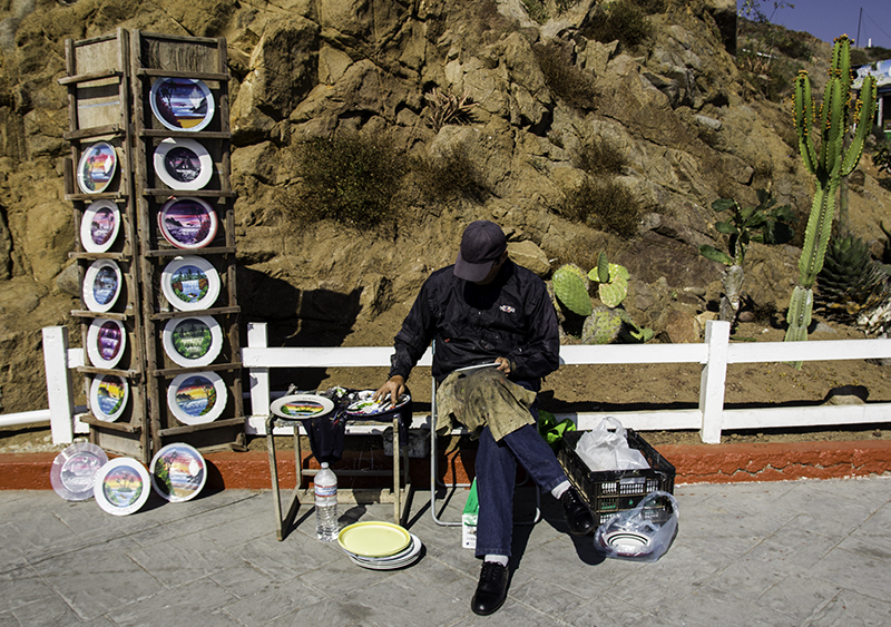
man finger-painting plates

man finger-painting plates

I made fun of his reaction once we were stopped. I know how it is to be a scared passenger, but that usually consists of being in a sports car speeding and weaving between vehicles and slamming on the brakes before hitting another car – not the case here. I get out to take pictures of the palm frond umbrellas on the beach and notice a sign that warns us not to swim on the dangerous beach with a picture of a man being swallowed on both sides by high waves. There are also no cars or dogs allowed on the beach, but fruit to eat and horses to ride are being sold. I get the romantic gesture, but I feel bad that the equine have to stand tied to a wall while they wait.

Smoke break is over and it’s time to get back on the road. Out in the water are boats and their large net traps to supply restaurants and food carts with local seafood. As we leave Ensenada, and the toll road, the quality of the street decreases. I run over the first speed bump of the day and it’s no joke. I was distracted by a dog riding a horse on the left and no warning sign on the right. Luckily the next two are painted, easier to see, and have a sign to accompany them – which to me looks like a symbol for road boobs.

We get to have a laugh about that before driving on the dirt road under construction – where there are still signs leading us to La Bufadora. The road goes out on the peninsula and almost doubles back before coming to a parking lot. We are directed to park outside of it for $2.00. I thought the vendors would be selling from carts, but the street to the blowhole is lined with shops offering pina coladas, bags, dresses, hammocks, and toys. There are restaurants and a spot offering to take my picture while I hold a lion cub.

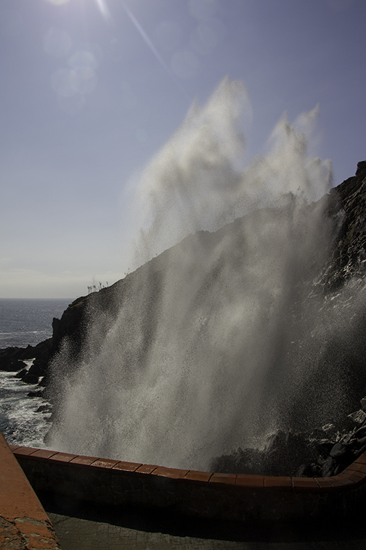
Past the bathrooms and men selling finger-painted scenes on plates to the viewing platform with two levels. We head down the steps after admiring the view, rocks, birds, waves, and taking some pictures of ourselves. The water comes into a tight point in the rocks where the pressure build up has nowhere else to go but up. Sometimes it’s just a cough of mist, but other times the water comes gushing up over the rocks and covering the viewers in a large cloud of mist while cascading back down with a hundred little white waterfalls. The amount of moisture and sun is a perfect environment for the moss growing which adds to the life and beauty of this blowhole.

There is a lot of energy and excitement as people wait for the picture-perfect moment as the water sprays almost like a manmade fountain dancing to the music of the Earth. Climbing is prohibited on the rocks, but there are supposed to be kayak tours that allow visitors another view. There will be no water-sport activities for us today, so we make our way up the stairs for a different elevated look at the water, rocks, sky, and people – who are smoking, drinking, dancing, texting, and taking pictures.

La Bufadora

La Bufadora

We would love to stay longer and explore more, but we still have a return drive of two hours with a planned smoke stop or two along the way. Caleb had pesos burning a hole in his pocket and bought me a pina colada in a pineapple. I shared the fruit with the guys and the drink with Dan because Caleb doesn’t like coconut. I let Caleb drive us to the outskirts of Rodolfo Sánchez Taboada where we stop for tamales so that I can keep both hands on my beverage.

At this food stand are jars of honey and spiced olives, peppers, carrots, and cauliflower. Tamale flavors are pepper and cheese (what Dan got – delicious), corn (what we got – too sweet), and chicken, etc. I let Caleb eat most of the tamale while I filled up on carrots. The tamales are cooked on a long stone stove in big pots on separate burners – metal grate over rock (resembling cinder blocks) between fires burning wood below. After we are back on the road I think about the tamales I should’ve bought to eat later.

Then we are at a military checkpoint. I roll down the windows on the driver’s side so the guy can look in. He says something and when I fail to do anything he sighs and says, “Go!” I’m glad that’s the only thing he said. It’s more difficult to visit another country or region with a different official language. I’m grateful that English is so world-wide and most symbols are so easy to understand.

We are halfway to the border when I decide to stop at Alisitos K-58, not for the restaurant or campground, but for another opportunity to visit the beach. From the cliff-side is a concrete ramp that takes us past green bushes and handful-sized rocks to soft sand. There is plenty of reflection from the tide on shore – washing up kelp and shells, some of which Caleb will collect to remember our time here. This beach is just as beautiful and barren as other beaches in California and Oregon – just the way I like ’em – us and nature.

beach near

beach near Alisitos K-58

That will be our last stop until we see brake lights at the border. We get into the second lane – and wait. Dan will smoke twice while walking beside us as we wait our turn to re-enter the United States. By avoiding eye contact we are able to keep most vendors peddling their wares elsewhere, but some prefer to tap on my window or shout their sales. The sun sets and I start to think about the veggie burrito I’m going to have when we get to Rubio’s Fresh Mexican Grill – a fast-food place on H Street.

About 50 minutes later and we are at the cameras, lights, and officers. I hand over three passports and the border agent asks about the owner of the vehicle, where we went, and if Caleb was active duty – which apparently need a permission slip to be in Mexico because they could’ve left their command without their officer-in-charge knowing. Weird then, that we can enter freely and stay as long as we want, but only when we want to return would their be trouble; which there would’ve been had he been caught. He told work he was taking me to a doctor’s appointment.

Caleb told the guy that he left his leave chit at home thinking he only needed it to visit Tijuana. We were going to be made to go to secondary inspection where an officer would call Shore Patrol that would verify Caleb’s story and then perhaps attempt to contact his command that is currently ship-less. And when that didn’t work out is what I was worried about – that and my hunger. The agent decides to let us go this time and I can be nothing but thankful. Caleb says he could’ve texted his friend to save his ass, but I’m glad we didn’t have to go through with all that nonsense. That will not happen again.

Dinner is at Rubio’s. Dan is able to call his wife on the way to let her know we made it back and he will be home after we get something to eat. I get a veggie burrito with chips, two sauces to dip them in (a green sauce that tastes like red salsa and a smoky chipotle), and some onions with cilantro. The guys got three fish tacos each. We had a great day. We got to try new things and tried our luck. We got home after 9:00 pm and after some notes about the events of the day it was time for bed.

Posted in Animals, Art, Food, Friends, Government, People, Places, Travel, Water | Tagged , , , , , | 1 Comment

Sunset Sayonara

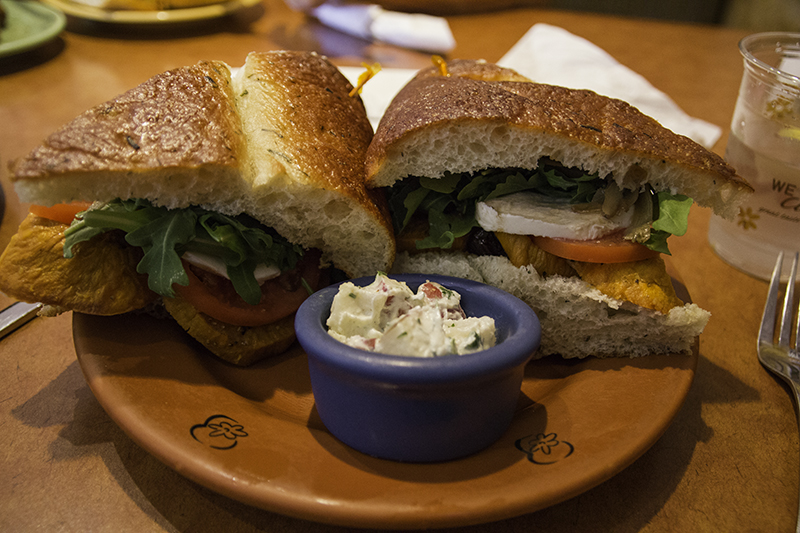
sweet potato sandwich from Wildflower Bread Co.

sweet potato sandwich from Wildflower Bread Co.

Today marks the last day of our trip. We have been on the road for almost four weeks – today is the 27th post in this chapter. We will spend the morning with my dad. We take Caroline to work, drive to U.S. Egg, and then decide to eat at Wildflower Bread Co. instead (my choice). Once there, Caleb and I will split a sweet potato sandwich (with leftovers) and a short stack of lemon ricotta pancakes.

Back at the house, the guys get into discussion for an hour or two and then it’s my turn on the Oculus in videos of my dad’s choosing. I get to watch a song on stage, Beers, Steers, and Queers, by Revolting Cocks in a movie theater. It’s neat to be able to see the light projected on the screen, and to have to navigate around the chairs and down the stairs. It feels like being in two worlds at once; I can feel Sparky’s paws on my leg and my dad’s hand moving in front of my face, but I’m also in a dark theater with a show on stage.

Dad at Szechwan Palace

Dad at Szechwan Palace – by Caleb

Then it’s time for my dad’s lunch date with Grandma at Szechwan Palace. Of course we’re invited. We skip the Americanized lunch specials menu to eat something more authentic. Grandma ordered some dumplings and water-boiled meat for the three of them to enjoy. Then we got sautéed green beans, ‘lettuce-asparagus’ (resembling yu choy sin), and tea tree mushroom with bean sprouts, celery, and jalapeño in a hot pot for all of us. These foods were spicy and we sounded like a classroom of 3rd graders with runny noses.

There was plenty of food to go around, and just as much conversation and spills in this family, that we had leftovers. Back at the house my dad gives us an ultimatum: stay with them for another week or go home now so that Caleb has a day off before going back to work. I’d love to wait for Caroline to get off work, but then we wouldn’t be home until midnight. We pack up and are out the door at 2:30 pm.

Exit 111 - Forrester Rd

Exit 111 – Forrester Rd

We are able to bypass a haboob as we ride home with mixed feelings. We are leaving 116 degree weather for what should be 70 degrees in San Diego. The sky is beautiful and there is the call of the road, but also the need to go home so Caleb can earn more travel money. I like the freedom of the road. Home seems to offer such a set schedule, but that’s probably Caleb’s job, tending to dogs, cleaning house, cooking meals, and entertaining friends – just like being on the road with Caleb navigating, walking the dogs, cleaning the tent, cutting veggies and meeting strangers.

We get to watch the sunset and pull in the driveway at 8:15pm. I grab a few things out of the car and then head to Dan’s for some lemonade to let him know we are home and thank him for keeping an eye on the place. Caleb had made coffee and forgot to wash the filter. We forgot to bring my bottom woolies and marshmallow sticks among other things. Looking at our credit card statement we could’ve saved $40 in foreign transaction fees by using the ATM just one more time.

the Bungled Jungle purple rabbit

the Bungled Jungle purple rabbit

On this trip we covered 10, 334 miles averaging 383 a day. Parts of it will be forgotten, but others will remain in these posts, photos, and stories we tell over the years. I was able to cross three items off my Before Eternal Planking list. Caleb and I saw 20 national parks and monuments, six of Canada’s provinces and seven of their national parks. We met his Aunt Jamie for two minutes, saw four of the Great Lakes, and got attacked by a hundred mosquitoes.

We discovered new plant life, ran and lingered on trails, and got stuck in traffic while it rained. We shopped, we saw, we skipped, we swam, we smiled. Sometimes we were too early or too late and we tried to stick to activities that were free. We learned about the past and thought about the future. We got to watch the sunrise from Cadillac Mountain and sit in the U.S. Center Chapel. We got to enjoy another meal at Swingin Steak and ride home into the sunset. A fairy tale ending to a real story.

Posted in Art, Entertainment, Family, Food, Things, Travel | Tagged , , , , , | 1 Comment

A Day in Navajo and Sinagua History

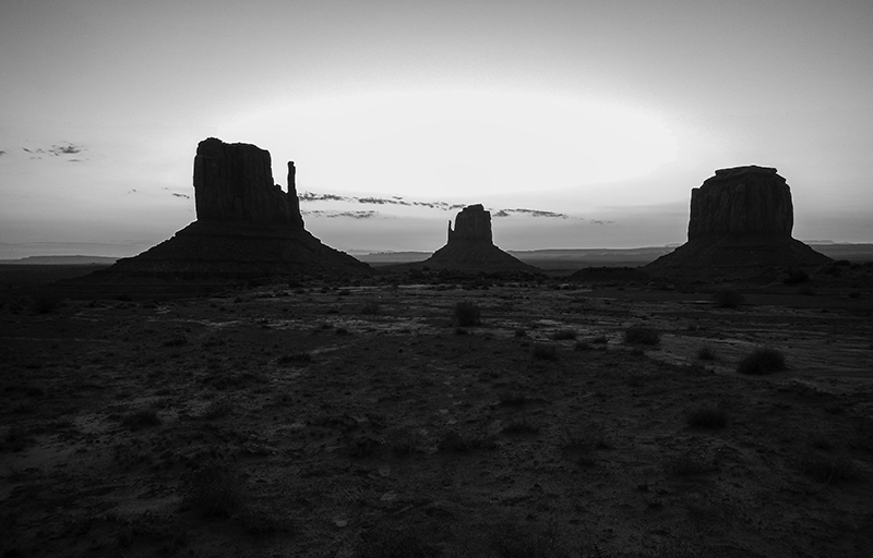
sunrise in black and white - by Caleb

sunrise in black and white – by Caleb

Up before the sun with the monumental shadows looming in the distance calling us towards them. There are other roads that get you near the buttes and formations for free, but I think it’s worth the $5 this morning to get a closer look. We are one of three cars that opt not to watch from the parking lot, but from between the West and East Mitten Buttes. There is red dirt with patches of green grass and spots of yellow flowers. There are shades of blue hills on the horizon and purple clouds on an orange sky.

To watch the sun rise we are always staring at the sun or maybe watching it bring color to the world behind us through trees and over mountains. I wonder what the sun’s view is like always bringing light to what it sees and leaving darkness for the moon to reflect its light on. That makes it sound like the sun rotates around the Earth, but it’s just a burning star that averages a distance of eight light minutes away – close enough to warm and far enough not to cause fire and only burn human skin after long exposure.

Now that the sun is up we can start the Valley Road tour. There are 11 numbered spots on the map of mesas, buttes, and spires, but plenty more to see. Some fit their descriptive name easily and others require more work on the imagination. We make it to stop 5 where there will be food and jewelry and other vendors available to tourists that visit later in the day and decide to turn around. The road is obvious, but not very weathered.

sunrise in Monument Valley

sunrise in Monument Valley

Back at the visitor center we look at the rugs, pottery, postcards, books, and t-shirts of the trading post. I was hoping for something special in the restaurant – unlike the eggs and corn flakes they had available on the simple buffet – so sandwiches will be had at the car. On the drive south the terrain begins to look familiar and I start to describe canyon dwellings that I saw on a trip with my dad in February – the same ones Caleb and I tried to see years ago and the same ones we will be seeing today at Navajo National Monument.

My first time here we took a dirt road, the second time everything was covered in snow, and today would be perfect – considering we didn’t know what time it was because Arizona doesn’t participate in Daylight Savings Time, but all the reservations do. Where there was snow there is lots of rock. Where there were freezing toes there are now warm wiggly appendages anxious to see more – like the Aspen Trail that branches from the Sandal Trail – the sign and path had been covered in snow.

Caleb notices men working in the Betatakin Dwellings and we point them out through the scope provided to the elderly man who is standing next to us. Then we all wonder how we can get down there and join them. We are quick to learn in the visitor center as a guided tour is five minutes from departure – perfect timing, but we have dogs in the car that probably won’t last 3-4 hours. We really should find a sitter for them as they keep us from doing so much on the road. Tours are offered the last week of May to the first week of September – at least this season.

coming up the Aspen Trail in Navajo National Monument

coming up the Aspen Trail in Navajo National Monument

Arizona is covered in national parks and monuments dedicated to nature and Native Americans, having almost as many as California that has 49,000 more square miles to accommodate their landmarks, the state of New York with only 54,000 square miles of land area to show off early history and old buildings, and the District of Columbia coming in with a measly 68 square miles to represent presidents and wars. It will still take us two hours to get to the next stop – Wupatki National Monument.

As soon as I see the entrance sign I can’t help but remember coming here with my dad too. It was one big tour and a great way to build on our father – daughter relationship. I remember posing in the window of the sign and then standing on a bridge in front of Sunset Crater distanced about 29 miles from each other. This land was used for farming in the 1100s, cattle ranching starting in 1880, and in 1924 became a monument that is today 33,000 acres larger than what President Coolidge established.

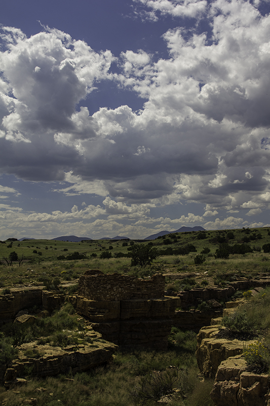
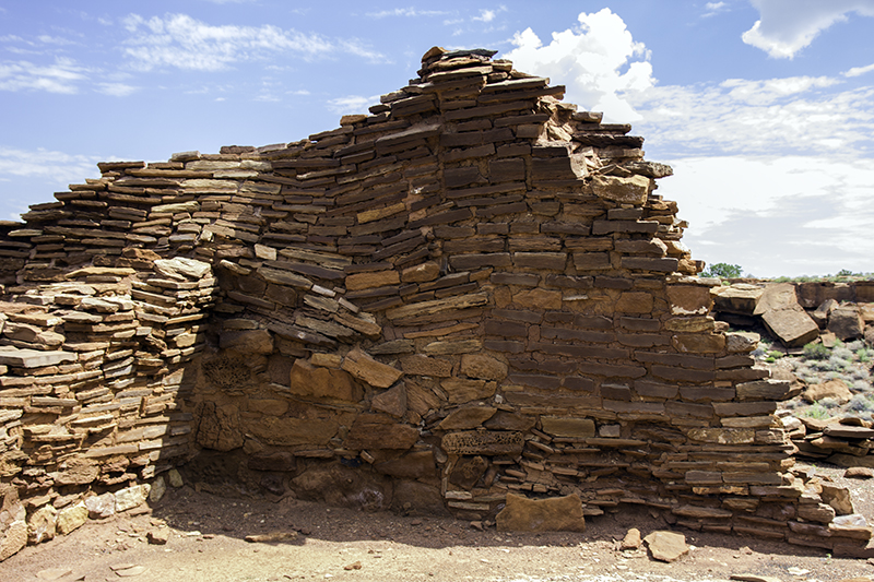
The pueblos look like extensions of the land that surrounds them, stone homes built upon the limestone and sandstone with chunks of basalt and local soil mortar to hold it all together through weathering and vandalism for over 700 years. There is an Asian family that moves quickly by the Box Canyon dwellings and a woman that resembles any explorer in a popular film that has joined us at the Citadel Pueblo – excellent views, but still ten miles from the Little Colorado River when no rainwater was caught.

near Gray Mountain on Hwy 89

near Gray Mountain on Hwy 89

So much effort had to go into living – hunting large game, searching for water, gathering nuts and seeds, making clothes, and building homes. They had to survive drought, floods, tornadoes, volcanic eruptions, and snow storms. There was fighting for land, trading for goods, and teaching the next generation how to work hard and die young. If ever someone in the modern age feels bored they could resort to doing things the way their ancestors did or get inspired to create something that will give us even more free time and longer lives.

I like to think that the Sinagua people had it easy and maybe they did until they were forced to move from their land of making a living, so that new settlers could use the land to make money. And as easy as I live today, a spoiled navy wife, I wonder if in the future we will appear as simple-minded as Australopithecus or will human kind be worse off in the future and make us look like the Stephen Hawking to Terence Tao era of our planet has reached its peak.

Through the visitor center and there is some small talk about travel, military, and love of history. Outside is the Wupatki Pueblo, possibly a gathering center for ceremonies and trade. The side facing us is closed off for either archeologists or for repairs. Either way, we go around back to see the different building styles and to learn more about what happened in which rooms and why. The pamphlet described items in the surrounding area – a shard pile, the ballcourt, and the blowhole – a crevice in the Earth that breathes (blows out or sucks in) depending on the barometric pressure above ground.

me in the sign

me in the sign – by Caleb

On our way back to the parking lot we meet Ranger Holly who earns herself a signature in Caleb’s passport companion by talking more about the architecture and history of the place. Then we are off to Sunset Crater Volcano National Monument. Visitors were once able to climb the cinder cone until the park realized the damage to the volcano and to the fallen hikers – falling on igneous rocks that are sharp and brittle is no fun.

We stick to the path and a volunteer tells us about the view of inside the crater from atop O’Leary Peak – an 8.7 mile hike that brings you to 8,916 feet of elevation in the Coconino National Forest. It takes awhile for plant life to come back after being destroyed by an eruption. There are enough ponderosa pines and Scarlet gilia to add a touch of green and red to the landscape of black in variants of sand and rock covered in lichen.

In the visitor center we learned about the devastating effects of ash when it buries 64,000 acres of farmland and about the effectiveness of seismometers to detect even the tiniest of vibrations in the earth. They are spread out in low-risk regions and concentrated in high-risk areas. I wonder about their coverage area as I start the car to go to Walnut Canyon National Monument. On the way we debate whether we will be able to see another park and camp there or drive to my dad’s house to spend the night.

Box Canyon dwelling

Box Canyon dwelling

I call him to settle the issue and there won’t be enough daylight to enjoy the other park today. We will visit the cliff dwellings of the Sinagua and then make our way to Phoenix. We are one of five cars in the parking lot along with the construction vehicles. There is some landscaping going on and something involving a pulley system to deliver materials along the west side of the Island Trail that is closed to visitors while they work. While getting the stamp for my passport one of the rangers notices a badge from another park and ask if we would like to become a Junior Ranger for Walnut Canyon – sure!

A lot of the answers can be found in the museum and in the educational video. Caleb gets to write a sentence using some Hopi vocabulary and interpret a petroglyph and then draw one of his own. The Island Trail consists of 240 steps to ease the 185-foot climb back up to the rim. Going down is fun, easy, and exhilarating – thinking about the work it took to build homes here and then catch animals and cook them in the cliff side, but also the health benefits of all that exercise, or the sore knees and back from all the climbing.

I get all giddy when I look across the valley and see more dwellings. Caleb assures me there are plenty in the area, but each one brings more excitement and a smile to my face that more history has been preserved and that I’m lucky enough to see it – and to be close enough to go inside some of them. I can see their fingers packing mud between rocks to glue the wall together and smell roasting pronghorn. The rooms are camouflaged well and Caleb smiles as I seem to notice more of them on the return trip.

Citadel Pueblo

Citadel Pueblo

Going back up the stairs I notice the steepness and the heat of the day more. Once Caleb’s workbook is reviewed he is sworn in by Ranger Erin who encourages me to take pictures of the accomplishment of my bearded man-child. I’m glad that the junior ranger program isn’t restricted to 12 and under (like the children’s menu at restaurants). I think adults need to learn things (and eat small meals sometimes) through the eyes of a child.

The road leading into the canyon is the same one we will take out of the park and towards Flagstaff. The fields are blanketed in yellow – what a sunny, bright, and happy sight. There are plenty of detours that we could’ve spent the rest of the day on, but the decision was already made to join my dad for dinner. I would get on Hwy 17 that would take us all but 20 miles of the way – the fast, don’t-look-out-the-windows way.

We arrive a little after 6:00 pm and this will be Caleb’s first time seeing an Oculus in person, so my dad lets him try it on and shows him a video of a rollercoaster ride – the one where lots of people have experienced motion sickness because their bodies are still, but their minds are being tossed around on rickety old wood pieces built through a village with a jump connecting the track before it loops back to start over. Caleb almost falls out of the chair and lets us know it’s hard not to lean your body with what your brain is seeing.

Who built this wall at Wupatki Pueblo?

Who built this wall at Wupatki Pueblo?

We take showers to wash off the last few days before Caroline gets home and then we drive to a new Indo-Chinese restaurant, Inchin’s Bamboo Garden, across town. My dad was looking forward to ethnic inspired drinks, not Coca-Cola, and entrees with a different flavor, not all the same. This place charges a $1.00 to make a meal without sauce; weird to be charged for something you’re not using. The service was bad and the food didn’t stand out, but we had dessert at Cheesecake Factory to look forward to. Caleb and I split a piece of chocolate raspberry cheesecake and we all got a cup of coffee.

Back to the house some time after 8:00 pm and we are settling down for a night in our pajamas of talking, knitting, and watching YouTube videos. I think I was tending to the dogs when my dad asked me to go near the window. I thought I was going to move the curtain and let some air in, or get a magazine for him to reference something, or grab a sample of one of Caroline’s weaving projects, or pose for an image capture via the Kinect. Then I was asked to look inside the mouth of a purple rabbit about two-feet wide by three-feet tall.

Inside this giant rabbit’s jaws is a mirror. I was asked what I saw and named something behind me. My dad commented that it was a weird description of myself. Then he tells me that the person in the mirror is the new owner of it. What?! This and his purple couch were the things I fell in love with when I first saw them. It is being gifted to Caleb and I as a fifth anniversary present. I would’ve been more than grateful for any one of their smaller Bungled Jungle creatures and find it hard to grasp that they are willing to part with one of their larger pieces.

Caleb in Walnut Canyon

Caleb in Walnut Canyon

Relationships are greater than any material item that represents them, but if one couple can share a piece of their history to build on another then it makes the item and the two relationships stronger. Feeling loved and lucky I want to cry; we joke that the rabbit could use the bath after being on the wall for so long. I will blot some of the dust with a handful of paper towels. The coffee and excitement and joy of being around each other keeps us up until midnight before we decide to hit the mattress. Good night.
Posted in Art, Camping, Family, Food, History, Marriage, Media, Photography, Places, Plants, Travel | Tagged , , , , , , | Leave a comment